Managing Urban Spatial Growth
Chapter 3 | Effectiveness of the World Bank in Enhancing Clients’ Capacity to Manage Urban Spatial Growth
Highlights
The World Bank has sought to build clients’ land administration capacity mainly through land titling, land-use certification, and strengthening institutions, but support for these activities has been decreasing over time.
Enacting improved laws and legal frameworks related to land administration takes longer than expected because the laws often raise sensitive issues about land and are set in a complex political economy that constrains implementation.
International Bank for Reconstruction and Development countries have been more successful than International Development Association countries at addressing land records data management systems and improving land titling. This has been due mainly to lower government capacity.
Support for land-use planning has been generally effective. Land-use regulation was effective when implemented with strong political commitment and when improved regulation was enforced.
Spatial planning activities were achieved when they were implemented through strong land-use planning frameworks and supported locally.
Despite good results at the portfolio level, case studies show challenges related to the sustainability of spatial plans and institutions and their ability to cope with urban growth.
World Bank support for urban transport focused on access and mobility has been effective. Support for urban transport focused on land-use integration has been limited.
Although World Bank urban upgrading and urban transport projects have been successful, they rarely consider land prices and land markets, which limits their ability to assess land use, value increases, and their distributional impact.
This chapter assesses the World Bank’s effectiveness at increasing clients’ capacity to manage urban spatial growth. As indicated in chapter 1, the effectiveness assessment is based on a focused portfolio covering 250 projects (132 closed and evaluated and 118 active) that included support for land administration, land-use planning, and land development in 19 countries. This portfolio represents about 54 percent of the entire World Bank activity in these areas and is mapped mainly to the Urban, Disaster Risk, Resilience, and Land and Transport Global Practices. The portfolio review analysis has been complemented with four field case studies (Colombia, India, Kosovo, and Mozambique) and four desk case studies (Ethiopia, Ghana, Rwanda, and Vietnam). The analysis focuses on land administration, land-use planning, and land development projects.
IEG rated 75 percent of closed projects in the focused portfolio as moderately satisfactory or higher (table 3.1). Land development through urban transport was the most common focus area (179 projects), and projects targeting land development through urban transport were also the most successful (rated moderately satisfactory or higher 79 percent of the time). By contrast, land development through urban upgrading was the least common focus area (50 projects) and also the least successful (rated moderately satisfactory or higher 69 percent of the time). However, the project outcome rating alone does not provide insights into some aspects of the management of urban spatial growth. This is because, to a large extent, activities related to urban spatial growth are small components within larger projects. For this reason, this evaluation took a closer look at specific project outcomes and implementation challenges related to activities relevant to the management of urban spatial growth.
Table 3.1. Project Outcome Rating of Focused Portfolio Projects
|
Focus Area |
Projects (no.) |
IEG-Evaluated Projects (no.) |
Outcome Rated MS+ (percent) |
|
Land administration |
58 |
32 |
71 |
|
Land-use planning |
118 |
60 |
75 |
|
Land development through urban upgrading |
50 |
26 |
69 |
|
Land development through urban transport |
179 |
101 |
79 |
|
All focused portfolio projects |
250a |
132a |
75 |
Source: Independent Evaluation Group.
Note: The order of focus areas in the table follows the framework introduced in chapter 1. The 19 countries included in the focused portfolio are Afghanistan, Bhutan, Brazil, China, Colombia, El Salvador, Ethiopia, Ghana, Haiti, India, Kenya, Kosovo, Mozambique, North Macedonia, the Philippines, Rwanda, Tanzania, Turkey, and Vietnam. See appendix A for selection criteria. IEG = Independent Evaluation Group; MS+ = moderately satisfactory or better.a. The total number of projects, which could be coded with multiple focus areas.
Land Administration
World Bank support for land administration has shifted from Europe and Central Asia to Africa. Regional trends are analyzed using the overall portfolio, which includes 115 land administration projects in 47 countries.1 The World Bank has had a prolonged engagement in Europe and Central Asia since the early 1990s and has seen a relatively large improvement in the quality of land administration there. More recently, the World Bank has shifted its support to Africa, the world’s fastest-urbanizing region, where the quality of land administration is lower and demand is higher. From 2000 to 2019, land administration support to Europe and Central Asia decreased from 52 to 23 percent by commitment volume (25 to 22 percent by number of projects), and support to Africa increased from 5 to 19 percent by commitment volume (17 to 35 percent by number of projects). Support to low-income countries has also increased from 4 to 20 percent of project volume (18 to 36 percent by number of projects); the quality of land administration tends to be low in low-income countries. Mozambique and Tanzania, both rapidly urbanizing countries, and Afghanistan, a conflict-affected country with a significant backlog of land administration needs, account for about 64 percent of low-income support by volume and 80 percent by number of projects.
The World Bank sought to improve cadastre modernization, but support is decreasing over time. The World Bank has in-depth experience in the design, implementation, and management of land registration and cadastral programs. Since the 2000s, World Bank support for land administration has focused on the modernization of national land administration systems (World Bank 2013b). In line with this focus, World Bank urban land administration projects in the focused portfolio have supported improving cadastre modernization, primarily through land titling and land-use certification (60 percent of projects) and strengthening institutions (57 percent of projects; table 3.2). The World Bank has placed less emphasis on strengthening laws and legal frameworks (34 percent of projects) and land records data management systems (29 percent of projects). However, from the first half of the evaluation period to the second half, the number of projects in all areas of support decreased.
Table 3.2. Land Administration in the Focused Portfolio, FY00–19
|
FY00–19 |
FY00–09 |
FY10–19 |
||||
|
Indicator Type |
(no.) |
(percent)a |
(no.) |
(percent)a |
(no.) |
(percent)a |
|
Land records data management systems |
17 |
29 |
12 |
38 |
5 |
19 |
|
Land titling and land-use certification |
35 |
60 |
21 |
66 |
14 |
54 |
|
Strengthening institutions |
33 |
57 |
19 |
59 |
14 |
54 |
|
Strengthening laws and legal frameworks |
20 |
34 |
12 |
38 |
8 |
31 |
|
All projects |
58b |
n.a. |
32b |
n.a. |
26b |
n.a. |
Source: Independent Evaluation Group.
Note: FY = fiscal year; n.a. = not applicable.a. This column shows the projects with a given indicator type (the row) as a percentage of the total number of projects.b. A single project can be coded with multiple indicator types.
Strengthening laws and legal frameworks related to land administration takes longer than expected and is a major challenge in the focused portfolio. Only 57 percent (8 of 14) of projects in the focused portfolio were successful in addressing laws and legal frameworks related to land administration challenges that contribute to urban spatial development and sustainable growth (table 3.3). The process of enacting improved laws and legal frameworks related to land administration typically goes beyond project completion because the laws often raise sensitive issues about land and are set in a complex political economy that constrains implementation. In Brazil, for example, the Integrated Municipal Development Project (2008–13) proposed a law that supported the creation of a multipurpose cadastre; the law was drafted but was not adopted by project closure because the reform was highly dependent on the specific interests of the administration. North Macedonia is a successful case of legal reforms that improved efficiency of land administration and the functioning of the real estate market (box 3.1).
Table 3.3. Evaluated Land Administration Portfolio Achievements, FY00–19
|
Indicator Type |
Achieved Total (no.) |
Achieved (percent) |
|
Land records data management systems |
14/17 |
82 |
|
Land titling and land-use certification |
12/17 |
71 |
|
Strengthening institutions |
11/16 |
68 |
|
Strengthening laws and legal frameworks |
8/14 |
57 |
|
Total |
24/32a |
75 |
Source: Independent Evaluation Group.
Note: a. A project can be coded with multiple indicator types.
Strengthening institutions, a key feature of land administration projects, has also been challenging when time and resources constrained implementation. In Afghanistan, a postconflict country, the World Bank delivered support within a compressed schedule that did not allocate enough time and resources for effective capacity-building activities. Private sector capacity, including in the construction industry, is limited in postconflict environments, and delivering capacity-building activities for private sector firms needs to be an integral part of the project design. In Vietnam, an International Development Association country at the time of project approval, the land administration project had implementation delays because of the low level of capacity and high turnover of staff at the local and provincial levels. Through training and technical assistance, however, World Bank support improved capacity within the public and private sectors (box 3.2).
Box 3.1. Links between the Improvement of the Legal Framework and the Efficiency of Land Administration and the Real Estate Market
The World Bank North Macedonia Real Estate Cadastre and Registration Project (2005–15) aimed to build an efficient and effective real estate cadastre and registration system, contributing to the development of efficient land and real estate markets. Key land and real estate policies were formulated and adopted. The new law allowed private surveyors and introduced procedures for systematic registration. The average time to record the purchase or sale of property in the land administration system fell from 30 days to just 1 day. After the reform, the number of transactions in land and real estate markets increased threefold. The number of mortgages using property as collateral increased more than fivefold in five years, from fewer than 3,000 to 17,000. These efficiency gains occurred against the backdrop of a general economic slowdown.
Four factors contributed to the outcomes of the project. First, an incremental approach to developing and rolling out the national electronic cadastre system allowed for technical adjustments and staff capacity building. Second, political willingness enabled the government to transfer cadastre-surveying responsibilities to the private sector. Third, improving procedures allowed better access to shared land and real estate data. Fourth, the institutional capacity of public sector institutions was strengthened at the national and municipal levels through training and technical assistance provided by the World Bank and bilateral donors.
Source: World Bank 2016b.
Box 3.2. World Bank Contributions to the Land Administration Reform Process in Vietnam
Since 2003, through the Poverty Reduction Support Strategy (World Bank 2015a) and Land Administration Project (World Bank 2016c), the World Bank has contributed to national and provincial land administration policy reform in Vietnam. The World Bank supported revisions and adoption of land laws in 2003 and 2013 and changes to associated regulations and decrees on land registration and service delivery that enabled the modernization of the land registration system and the improvement of land registration. Previous government attempts had failed to go beyond mapping and surveying. Nearly 1.3 million households were granted land-use record certificates under the project; 62 percent of the land-use certificates in the registry were held by women. The project also sought demand-side interventions to promote use of land registration and land-use data by the public. The success of the World Bank support was due to political will, institutional capacity, and the demand-side interventions. Focusing on the demand at a local level—by including training of government officials at all levels and awareness-raising campaigns targeting land users—was a key element. In all, some 3,356 participants received training under the project.
Sources: World Bank 2012, 2015b, 2016c.
In International Bank for Reconstruction and Development countries, land administration support has been successful at addressing land records data management systems and improving land titling. In these countries, 91 percent of projects (10 of 11) were successful at improving land records data management systems, and 90 percent of projects (9 of 10) improved land titling or land-use certification. In the Philippines, the Land Administration and Management Programs 1 and 2 (2001–14) improved land titling and land records data management. The focus of the programs was on strengthening links between the local government and the private sector, advocacy groups, and academic institutions, and on awareness campaigns in the community, all of which resulted in more than 100,000 new land registrations. Land titling more than doubled during the project period, with an average issuance of more than 7,000 property titles per year, in comparison to 2,624 titles before the project. The land administration program strengthened the perception of land tenure security. According to a survey within the project, the perception of land tenure security strengthened, from 77 percent of surveyed residents to 81 percent in Bohol from 66 percent to 96 percent in Bukidnon and from 83 percent to 84 percent in Leyte.2
International Development Association countries in the focused portfolio, by contrast, have challenges with land titling and land records data management systems. Strengthening land titling and land registration was achieved in 50 percent of projects (three of six), and improving land records data management systems was achieved in 67 percent of projects (four of six). In Maputo, Mozambique, the World Bank supported the development of an integrated citywide system for land administration. At the end of the second project, the system was able to partially function and contributed to improving the mass regularization of land-use titles. After project closure, the issuance of land-use rights certificates declined significantly, and the system created during the project did not have the necessary funding and updates to continue operating. Limited local and technical capacity and political economy issues—including changes of leadership due to political cycles and insufficient adaptation to local context—affected the achievement of results.
Land-Use Planning
World Bank support for land-use planning has increased and is concentrated in Africa and Latin America and the Caribbean. Regional trends are analyzed using the overall portfolio, which includes 258 projects that involve land-use planning activities in 75 countries. The World Bank has provided the most support to Africa, which accounts for 35 percent of land-use planning support by volume (29 percent by number of projects), followed by Latin America and the Caribbean with 27 percent (19 percent by number of projects). Colombia, India, Kenya, and Vietnam accounted for 61 percent of total volume (37 percent by number of projects). By providing land-use planning support to Africa, the World Bank is addressing land-use planning in a region that needs it most. Although East Asia and Pacific is a fast-urbanizing region, support to this region has remained stagnant at 15 percent by volume.
The World Bank has primarily focused on spatial planning and enhancing the capacity of planning agencies. Spatial planning is the basis for World Bank support for land-use planning. The World Bank recognizes that fragmented city planning across agencies and tiers of government—national, provincial, and district—results in inefficient city planning; it thus advocates for intergovernmental coordination and metropolitan-scale management (Baker and Gadgil 2017; World Bank 2013b). Of the 118 projects in the focused land-use planning portfolio across 19 countries, 75 projects (64 percent) implemented spatial planning, and 55 (47 percent) worked to enhance the capacity of traditional planning agencies that are under the auspices of the local mayor (table 3.4). Although street addressing support seems low (four projects in the focused portfolio), 21 projects (71 percent of them in Africa) in the overall portfolio included street addressing as a component.
Although the World Bank has been encouraging the establishment of independent planning agencies, it has not provided operational support for such agencies. The World Bank highlighted the creation of independent regional and metropolitan planning agencies in the 2009 urban strategy Transforming Cities with Transit (Suzuki, Cervero, and Iuchi 2013) and in the World Bank urban transport e-learning course. Interest in regional and independent planning agencies stems from the fact that they have low staff turnovers due to political cycles; they also have independent budgets and can address spatial fragmentation of land use. Avoiding fragmentation is important given its prevalence in the Urbanization Reviews; 10 out of 15 countries in the focused portfolio highlight this condition. These characteristics enable continuity and consistency in planning processes despite changes in city administration. Examples include the Institute for Research and Urban Planning of Curitiba in Brazil, the Seoul Institute in Korea, the Municipal Planning Institutes in Mexico, and the Regional Plan Association in the United States. The portfolio of 69 evaluated projects did not include any support to independent planning agencies.
Land-use planning components have performed well overall, but there is limited evidence regarding outcomes. In the focused evaluated portfolio, World Bank support improved land-use planning in 79 percent of projects (table 3.5). Although land-use planning activities were achieved in 74–85 percent of projects with land-use planning indicators, most of the indicators are related to output. Support was effective in land-based tools and street addressing activities, but there were very few such projects in the focused portfolio. In the overall portfolio, 70 percent of the street addressing projects were successful. Some factors of success were (i) strong municipal support in promoting signage systems and street addressing, (ii) collaboration within the land-use planning authorities, and (iii) ample capacity support.
Table 3.4. Land-Use Planning in the Focused Portfolio, FY00–19
|
FY00–FY19 |
FY00–FY09 |
FY10–FY19 |
||||
|
Indicator Type |
(no.) |
(percent)a |
(no.) |
(percent)a |
(no.) |
(percent)a |
|
Enhancing capacity of planning agencies |
55 |
47 |
23 |
46 |
32 |
47 |
|
Geospatial data and management |
30 |
25 |
17 |
34 |
13 |
19 |
|
Land-based tools |
4 |
3 |
0 |
0 |
4 |
6 |
|
Land-use regulation |
27 |
23 |
15 |
30 |
12 |
18 |
|
Spatial planning |
75 |
64 |
30 |
60 |
45 |
66 |
|
Street addressing |
4 |
3 |
1 |
2 |
3 |
4 |
|
All projects |
118b |
n.a. |
50b |
n.a. |
68b |
n.a. |
Source: Independent Evaluation Group.
Note: FY = fiscal year; n.a. = not applicable.a. This column shows the projects with a given indicator type (the row) as a percentage of the total number of projects.b. A single project can be coded with multiple indicator types.
Table 3.5. Evaluated Land-Use Planning Portfolio Achievements, FY00–19
|
Indicator Type |
Achieved/Total (no.) |
Achieved (percent) |
|
Enhancing capacity of planning agencies |
27/32 |
84 |
|
Geospatial data and management |
14/19 |
74 |
|
Land-based tools |
1/1 |
100 |
|
Land-use regulation |
17/20 |
85 |
|
Spatial planning |
30/40 |
75 |
|
Street addressing |
3/3 |
100 |
|
Total |
49/62a |
79 |
Source: Independent Evaluation Group.
Note: FY = fiscal year.a. A single project can be coded with multiple indicator types.
Support for land-use regulation has been generally effective in cases with strong political commitment and where improved regulation was enforced. Land-use regulation objectives were achieved in 17 of 20 projects (85 percent). The second Urban Development Project (2010–19) in Bhutan aimed not only at introducing land-use frameworks but also at supporting the implementation of policies, including the Bhutanese Architectural Guidelines, the National Human Settlements Strategy, the Spatial Planning Act, and Planning Regulations and Standards. The National Human Settlements Strategy had a major impact because it regulates the spatial and investment priorities of all public investments in Bhutan’s 12th five-year plan (2018–23). The Planning Regulations and Standards were also incorporated into local area plans, directly affecting the spatial considerations of all private investments in urban areas. In Kosovo, World Bank support helped establish the regulatory framework for land use. However, it was not fully implemented, and urban spatial growth has been negatively affected by the construction of 350,000 informal buildings that were not registered because the spatial planning and construction approval system, which was defined in law, was not enforced.
The objectives of spatial planning activities were achieved when they were linked to approaches with strong land-use planning frameworks and supported locally. Spatial plans at the regional, metropolitan, and neighborhood levels have been successfully delivered by project completion in 75 percent of projects, and the capacity of planning agencies was enhanced in 84 percent of projects. The World Bank supported Colombia through a development program–lending series (FY12–15) that modernized spatial planning through the Planes de Ordenamiento Territorial. These plans regulate land use and the implementation of eight department-level land-use plans, enabling the country to execute regional development programs. In the context of natural disasters and civil unrest, 35 territorial plans were developed. Locally based task team leaders and dedicated urban specialists were instrumental in ensuring successful implementation.
Despite good results at the portfolio level, case studies show challenges related to the sustainability of spatial plans and institutions and their ability to cope with urban growth. Integrated spatial planning is necessary to manage urban spatial growth, prevent the emergence of vulnerable urban areas, and reduce the risk of human loss and physical damage. Cities without strong planning frameworks relying on master plans have generally failed to guide urban spatial growth, as documented by the World Bank in Tanzania (box 3.3). In Ethiopia, the Urban Local Government Development Project sought to enhance the capacity of planning agencies by establishing planning offices to carry out provincial and local spatial land-use plans, but the process failed to enhance the capacity to address deficiencies at the provincial level. In the context of the Typhoons Ondoy and Pepeng Post-Disaster Needs Assessment (World Bank 2011b), the complexity of developing comprehensive land-use plans, updating them, and enforcing them have posed challenges for municipal planning administrations in the Philippines. Even after extensive support by the World Bank through CDSs, the Philippines’ comprehensive land-use plans lag. The main factors hindering successful implementation of these plans include political interference, complexity in planning policies, overlapping institutional mandates, limited capacities of local governments, and tenure conflicts. The government estimated in 2012 that 70 percent of municipalities did not have updated land-use plans (GIZ and ANGOC 2014).
Box 3.3. Challenges in Translating Plans to Development
Secondary cities in Tanzania where the World Bank has been active (Arusha, Dodoma, Kigoma, Mbeya, Mtwara, Mwanza, and Tanga) have had poor implementation of master plans. Although the plans have been somewhat successful in providing broad guidance, they were implemented only to a limited extent or were ineffective in guiding development in terms of land use. Actual development in core urban areas exhibited approximately 35 to 45 percent of land-use conformity to early master plans, and conformity varies greatly in peri-urban areas. The ineffectiveness of master plans is reflected in cities experiencing substantial unplanned growth including increased fragmentation; isolated developments form in the peri-urban areas with severe infrastructure and facilities backlogs, indicating that new investments are not growing fast enough to match the pace of urban growth.
Source: Cantada et al. 2018.
World Bank support for clients’ geospatial data and data management has been more successful when tailored to a country’s needs. Support for geospatial data management has been largely through the implementation and enhancement of geographic information systems (GISs) in low-income countries.3 These countries lag in the implementation of such systems and have a high demand for external support in establishing them. The World Bank’s support for the implementation of spatial data infrastructure systems in Ghana and Mozambique was not successful due to the reduced focus on capacity transfer and narrow focus of spatial systems on land administration without also considering the land-use planning needs. By contrast, in countries with higher capacity and income, the systems did not require international consultants and were designed and implemented by local agencies with strong ownership. In India, for example, the World Bank supported the Andhra Pradesh and Telangana municipalities in establishing GIS units and developing GIS. Some 69 urban local bodies completed GIS mapping.
World Bank support for street addressing in the focused portfolio has been effective but limited. Street names and numerical addresses assigned to land plots are essential to identify the physical location of households and to guide formal land development and upgrade informal slum settlements. Without a common system to identify plots, it is not possible to assign and register property titles. The focused portfolio includes three interventions with successful street addressing components. In Burkina Faso, support in Ouagadougou and Bobo-Dioulasso included 415 streets named, 140,000 doorways addressed, and 2,000 new street signs posted. Specific outcomes included matching addresses with the plots’ cadastral references and using addressing for street cleaning and collecting sanitation fees (Angel, Sheppard, and Civco 2005).
The World Bank has promoted but rarely supported the implementation of preventive land-use planning tools to manage urban spatial growth. Governments use land-based tools in coordination with landowners and the private sector to help plan the type, intensity, location, and timing of new urban developments. The tools are necessary because they provide governments with the ability to consolidate tracts of land, enabling the introduction of public services and the definition of land use (see box 3.4 for a more detailed definition). They support the compatibility of new growth with surrounding uses and address the need to minimize the costs associated with supplying public services to support urban expansion. Of 258 projects in the focused portfolio, only four projects had land-based tools components.
Box 3.4. Land-Based Tools: Land Readjustment
Land readjustment is a land-based tool for assembling land for urban expansion or redevelopment. In land readjustment, the original landowners or occupants voluntarily contribute a certain percentage of their land to the government. In return, each landowner receives a serviced plot within the same neighborhood; this plot is smaller but often has a much higher value because the government builds roads, other infrastructure, public facilities, and open spaces. This is a win-win situation in which the government can upgrade the neighborhood without having to use its power of eminent domain (expropriation), and the landowners can remain in their original location and enjoy better living conditions and an increase in the value of their real assets.
Source: World Bank Open Learning Campus, “Land Readjustment,” https://olc.worldbank.org/content/land-readjustment-self-paced.
Support for land readjustment has also been effective but limited. Only one of four land-based tool projects in the portfolio introduced land readjustment to support the management of urban spatial growth. In Bhutan, the World Bank successfully used the land readjustment approach to develop 400 plots of land in the capital city of Thimphu. The land readjustment tool increased the satisfaction of households and increased the land available for orderly expansion of the city. Of the landowners, 72 percent were satisfied or very satisfied with the land readjustment process, and 73 percent agreed that land pooling is worth replicating elsewhere in Bhutan. Land pooling in Bhutan has provided the municipality with more than 100 hectares of land for building infrastructure and amenities, greatly reducing the up front capital the municipality would have needed if it had to acquire land compulsorily (World Bank 2015c).
Support for land readjustment in India and Vietnam exemplifies the complexities the World Bank faces when engaging clients with such approaches. In Amaravati, India, the World Bank provided technical assistance to design a land readjustment initiative that would have affected more than 21,000 landless laborer households. Mainly due to disputes between the landowners and the government, the project was canceled during preparation. In Tra Vinh, Vietnam, the World Bank provided four years of technical assistance to prepare a land readjustment initiative for about 1,000 parcels in an area of 25 hectares. The plan had the backing of 90 percent of households to proceed but was stopped because the legal framework for land readjustment at the central level was not finalized.
Land Development
Land development is the transformation in the uses of land through investments, creating public and private infrastructure. Managing urban spatial growth through land development is a priority to consolidate growth and reduce urban sprawl. Public investments in cities—such as the provision of public services—are designed to enable and motivate investment by the private sector in private and commercial real estate. Urban upgrading and urban transport are two particularly important aspects of land development, and they are discussed in the following subsections. The assessment of land development focuses primarily on fast-urbanizing countries where the benefits of early intervention to manage urban spatial growth are most significant (Ferguson and Navarrete 2003).
Land Development through Urban Upgrading
World Bank support for urban upgrading has focused on lower-middle-income countries and those in East Asia and Pacific. Regional trends are analyzed using the overall portfolio, which includes 91 land development through urban upgrading projects in 39 countries. Lower-middle-income countries account for 55 percent of this support by volume (48 by number of projects). East Asia and Pacific received the most World Bank support, with 40 percent by volume (21 percent by number of projects), followed by 19 percent by volume for Latin America and the Caribbean (31 percent by number of projects) and 19 percent by volume for Africa (25 percent by number of projects). Much of the support is concentrated in Brazil, Indonesia, and Vietnam, which together account for 40 percent by volume (30 percent by number of projects). Of urban upgrading support, 67 percent is directed toward moderate-urbanizing countries and 29 percent toward fast-urbanizing countries.
Urban upgrading interventions have focused on consolidating built-up areas (curative approaches) rather than managing urban expansion (preventive approaches). The focused portfolio of 50 projects in 19 countries reveals that the urban upgrading portfolio is focused on consolidating built-up areas through improving access to infrastructure (80 percent of projects) and access to housing (44 percent; table 3.6). By contrast, support to approaches that manage urban expansion—such as building new infrastructure and providing access to sites and services—have been limited to only four interventions (8 percent), all of them in the first half of the evaluation period.
Table 3.6. Focused Urban Upgrading Portfolio by Indicator Type and Period, FY00–19
|
FY00–FY19 |
FY00–FY09 |
FY10–FY19 |
||||
|
Indicator Type |
(no.) |
(percent)a |
(no.) |
(percent)a |
(no.) |
(percent)a |
|
Consolidation of built-up areas (curative) |
||||||
|
Improving housing |
22 |
44 |
13 |
52 |
9 |
36 |
|
Improving infrastructure and basic services |
40 |
80 |
21 |
84 |
19 |
76 |
|
Urban expansion (preventive) |
||||||
|
Introducing infrastructure and basic services |
4 |
8 |
4 |
16 |
0 |
0 |
|
All projects |
50b |
n.a. |
25b |
n.a. |
25b |
n.a. |
Source: Independent Evaluation Group.
Note: FY = fiscal year; n.a. = not applicable.a. This column shows the projects with a given indicator type (the row) as a percentage of the total number of projects.b. A single project can be coded with multiple indicator types.
The World Bank is generally successful in curative urban upgrading approaches. Eighty-three percent of projects in the focused portfolio improved access to infrastructure and basic services, and 72 percent improved housing (table 3.7). In Rwanda, the Urban Infrastructure and City Management Project contributed to opening up new areas to development. The construction of about 23 kilometers of asphalted and stone-paved roads increased circulation and access to roads in slums and poor neighborhoods. Project beneficiaries were satisfied with these local improvements, including increased mobility within the area; the public street lighting made people feel safer and changed the perception of the area as difficult to access and dangerous at night; better access to and from the area resulted in the creation of small businesses; and better roads provided easier access for emergency and security vehicles (World Bank 2018b).
Table 3.7. Evaluated Urban Upgrading Portfolio Achievements, FY00–19
|
Indicator Type |
Achieved/Total (no.) |
Achieved (percent) |
|
Improving accessibility to infrastructure and basic services |
19/23 |
83 |
|
Improving housing |
13/18 |
72 |
|
Introducing infrastructure and basic services |
0/1 |
0 |
|
Total |
19/26a |
73 |
Source: Independent Evaluation Group.
Note: FY = fiscal year.a. A project can be coded with multiple indicator types.
The World Bank had limited engagement in preventive approaches through the introduction of infrastructure and basic services and took significantly longer to show tangible results. In the focused portfolio, only 8 percent (4 of 50 projects) focused on preventive approaches. Of these, only one has been evaluated, and results have yet to materialize. The Urban Infrastructure and City Management Project (FY06–10) in Kigali, Rwanda, implemented a preventive approach aimed at “defining and testing new practices to help control urban sprawl” (World Bank 2005b, 8). A 33-hectare area in Akumunigo was developed and serviced with basic infrastructure for low-income households. Although serviced plots were distributed at project closure, land development was delayed due to lack of demand from developers. However, more recently, the area has received support to provide affordable homes from the Rwanda Development Bank in partnership with financial intermediaries and developers. The 1988 Mumbai and Chennai urban sites and services projects in India encountered similar implementation difficulties to those in Kigali, but after more than 30 years, sites and services showed tangible results (box 3.5).
Box 3.5. Success When It Was Deemed a Failure: Preventive Urban Upgrading Approaches in Mumbai and Chennai
In 1988, designers of the World Bank–financed Chennai and Mumbai sites and services projects in India set out to demonstrate that anticipating and managing urban spatial growth was possible in a manner that not only allowed full cost recovery of public investments but also enabled households to invest in and self-build homes incrementally. All sites in both Mumbai and Chennai were greenfield developments. The interventions introduced flexible land-use standards, a wide range of plots small enough for poor people to afford, and narrow roads. The projects included the development of mixed-use neighborhoods—with space for schools and clinics—located close to large trunk infrastructure and public transit investments in anticipation of city growth. At project closure, serviced plots had been delivered, the majority had been purchased by lower-income households, and full public investment costs had been recovered. Despite these achievements, these sites initially suffered low occupancy, and it was uncertain whether houses would be built incrementally or who would benefit. After project closure, however, these projects flourished, attracting low-income families who settled and created densely populated, vibrant, and thriving neighborhoods.
Source: Adapted from Owens, Gulyani, and Rizvi 2018.
Preventive approaches, including those with the characteristics of sites and services, often encountered problems as they met regulatory and policy limitations. Minimum plot size regulations may require plots that are too large and thus too expensive for poor people to afford. Similarly, building codes may not allow for the construction of homes in an incremental manner consistent with the way poor people often build their homes (Banerjee and Duflo 2011).
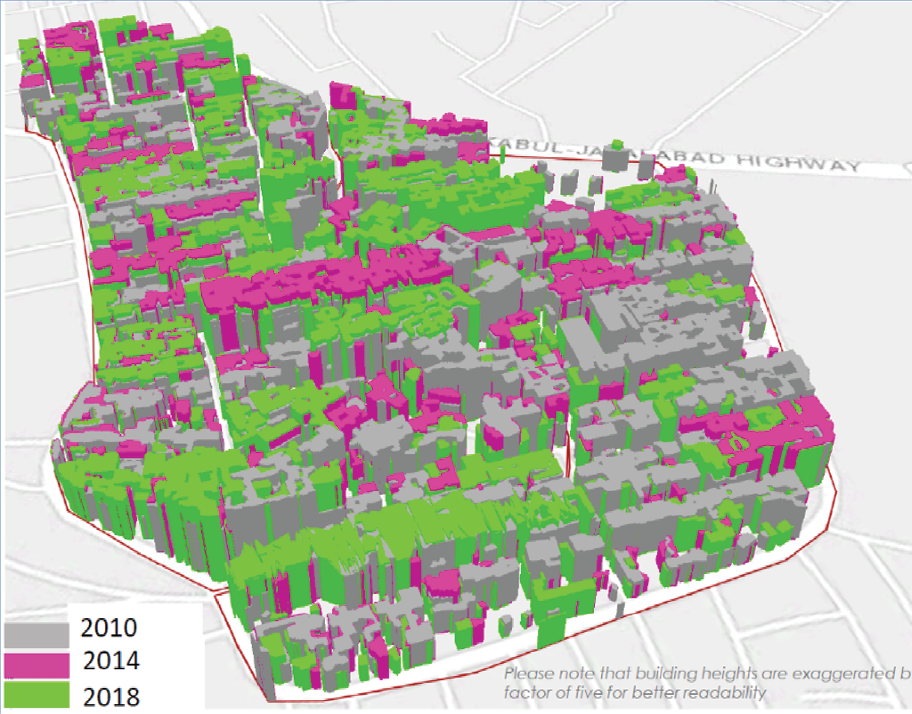
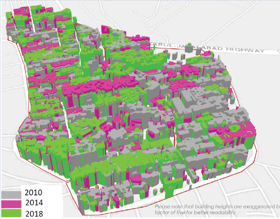
Although urban upgrading improvements in infrastructure provision and housing were successful, data to understand the full impact of investments in land use are not available. Without systematic data recording the precise locations of World Bank investments, it is impossible to assess their contributions to land development or their impact on spatial growth. Of the focused portfolio of 50 urban upgrading projects, data to understand the impact of the World Bank’s investments on land use are available in only one case. World Bank support for urban upgrading in the city of Kabul has carried out three-dimensional analysis using light detection and ranging technology to measure volumetric change and two-dimensional analysis to measure the change in ground coverage. The analysis allowed the quantification of the total amount of private sector investment leveraged in both upgraded and nonupgraded neighborhoods (box 3.6). The need for precise location data is discussed further in chapter 4.
Box 3.6. Impact on Urban Density of Urban Upgrading Support in Kabul
The World Bank supported urban development in Afghanistan through the Kabul Urban Reconstruction Project (2004–10) and, more recently, the Kabul Municipal Development Program (2014–21). These projects supported the land-use integration of selected neighborhoods into the urban fabric of the capital city through the reconstruction and rehabilitation of urban infrastructure and upgraded about 3,000 hectares. Public investments in upgrading have leveraged $3.8 billion in private investment in the upgraded areas—every $1.00 of public investment has attracted private investment of about $32.00, far exceeding the findings from earlier World Bank studies that indicated that every $1.00 in public investment leverages $7.00 in private investment. Studies done during supervision to assess impacts on built-up volume and densification of upgraded areas highlight an increase of total built-up volume by 5.54 million cubic meters in select settlements between 2010 and 2018. The density of land use increased from an average of 0.87 in 2010 to 1.14 people per hectare in 2018, indicating better use of existing urban land.a The real estate market value of properties in select upgraded areas increased by an average of about 36 percent between 2013 and 2015.
Figure B3.6.1. Impacts on Built-Up Volume and Densification of Areas in Kabul
Source: World Bank.
Source: World Bank.
Note: Land use is measured through the floor space index.
Property Values in Urban Upgrading Projects
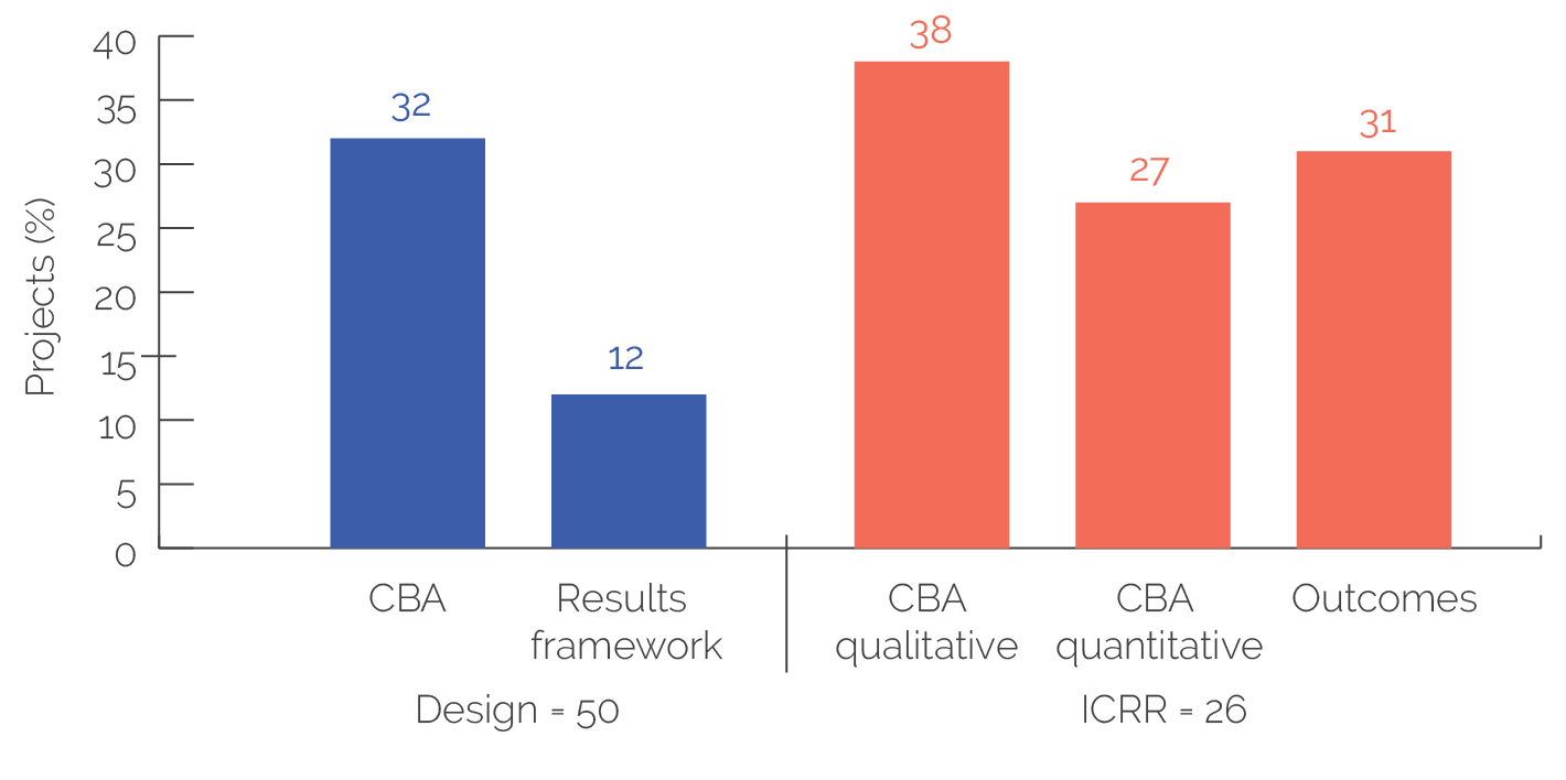
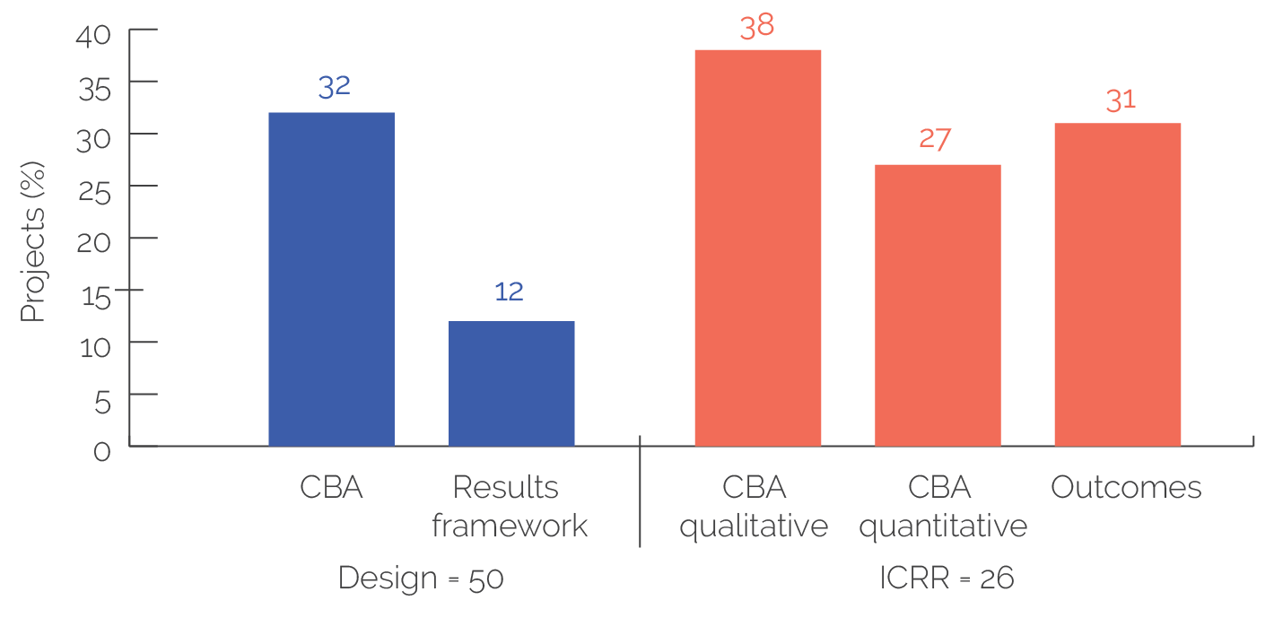
World Bank urban upgrading projects do not systematically consider land prices and land markets, limiting their ability to measure land-value increases and their distributional impact. Land value complements the measurement of urban form and land use and allows the estimation of demand for future development (World Bank 2020e). The World Bank has supported land market assessments since 1995. Land market assessments are based on citywide data collection and enable analysis over time of the geographic patterns and changes of land prices, land uses, formal and informal real estate market activities, and the demand and supply of land for different market segments or income groups. A review of 50 urban upgrading projects showed that, at design, 16 projects (32 percent) considered land markets in the cost-benefit analysis, and only 6 (12 percent) considered them in the results framework. At project completion, 10 of 26 projects (38 percent) provided qualitative measures of land values, 7 of 26 (27 percent) provided quantitative measures of land values, and 8 of 26 projects (31 percent) showed property values as outcomes in results (figure 3.1). Can Tho and Tra Vinh in Vietnam are examples that show significant price increases in residential areas as a result of World Bank finance investments (box 3.7).
Figure 3.1. Consideration of Land and Property Values in Urban Upgrading Projects
Source: Independent Evaluation Group.
Note: Four projects mentioned increases in property prices as outcomes but did not provide evidence. CBA = cost-benefit analysis; ICRR = Implementation Completion and Results Report Review.
Box 3.7. Land Market Assessments in Can Tho and Tra Vinh, Vietnam
A detailed land market assessment in March 2018 in Can Tho and Tra Vinh, Vietnam, revealed that World Bank support for investments in roads was accompanied by significant increases in land values, while land prices in other low-income areas that did not benefit from the project investment increased modestly. For land plots along upgraded primary infrastructure, market prices increased 5 to 11 times between 2012 and 2018 (compared with increases in out-of-project areas of 2 to 3 times). Although systematic data are not available, interviews suggested that most poor households in the low-income areas did not sell their houses after the project closure, and instead the residents upgraded and expanded their housing.
Sources: Adapted from World Bank Open Learning Campus, “An Introduction to Land Market Assessment in Complex Urban Settings” (https://olc.worldbank.org/content/introduction-land-market-assessment-complex-urban-settings-self-paced) and World Bank 2019d.
The lack of land-value data constrains the World Bank’s ability to estimate and monitor the quantity and accessibility of land for future development. Having evidence about land values is fundamental to define investments that support efficient urban expansion and land consumption consistent with SDG 11, sustainable cities and communities. In addition, the manner in which the World Bank appraises the viability of urban projects likely underestimates the full impact of the World Bank’s portfolio of urban infrastructure investments. Project teams may inadequately account for the potential long-term impacts of their projects and, in turn, may be less likely to design projects that effectively unlock potential wider economic impacts, including thinking through how property value increases could be anticipated and leveraged over the lifetime of the project (World Bank 2020c).
Land Development through Urban Transport
World Bank support for urban transport has increased over time and is most concentrated in East Asia and Pacific and in Africa. Regional trends are analyzed using the overall portfolio, which includes 316 land development through urban transport projects in 75 countries. The commitment to urban transport projects has doubled from $6 billion in FY00–09 to $12 billion in FY10–19. The World Bank has provided the most support in East Asia and Pacific, with 44 percent by volume (42 percent by number of projects), followed by Africa with 25 percent by volume (21 percent by number of projects). Support to East Asia and Pacific has increased over time from 33 to 49 percent of project volume (27 to 52 percent by number of projects). Fast-urbanizing countries accounted for 86 percent of project volume (77 percent by number of projects). China, Ethiopia, India, and Vietnam were the major destinations for support, accounting for 73 percent of urban transport investments.
Land development through urban transport involves infrastructure investments within the existing urban areas and in the periphery of the city to enable orderly spatial growth. Urban transport shapes urban growth by improving and opening access to land through investments in road and public transit infrastructure. Like land development through urban upgrading, these interventions shape the land use and growth patterns of cities, helping to define their productivity and inclusiveness. Considering land markets and fostering transit-oriented approaches to urban growth are essential to reverse urban sprawl and return to compact development patterns supported by high-quality transit systems (box 3.8).
Box 3.8. Transit-Oriented Development in Managing Urban Spatial Growth
Transit-oriented development is a planning and design strategy that focuses on creating urban development patterns that facilitate the use of public transit, walking, and cycling as primary modes of transportation. It supports vibrant, diverse, and livable communities by concentrating urban densities and activities within a 5- to 10-minute walking distance from mass rapid transit stations (both bus- and rail-based), developing quality urban space, and providing convenient and efficient access to a diverse mix of land uses. Transit-oriented development brings together elements of land use and transportation planning, urban design, urban regeneration, real estate development, financing, land-value capture, and infrastructure implementation to achieve more sustainable urban development.
Source: World Bank 2018c.
World Bank support to integrated urban transport interventions is limited and heavily concentrated on China. A review of the 179 projects in the focused urban transport portfolio revealed that most of the projects aimed to improve accessibility (64 percent) or mobility (52 percent; table 3.8). Although the number of projects targeting integrated land use increased from 7 in FY00–09 to 12 in FY10–19, these 19 projects represent only 11 percent of the portfolio. These integrated land-use urban transport interventions supported the formulation of land-use policies to strengthen land development and management. Sixty-three percent of the projects with integrated land-use targets were in China. Although land development considerations in urban transport projects are limited, the World Bank’s Urban Mobility Global Solutions Group is developing prototype theories of change that mainstream land-use considerations into transportation projects as guidance for operational teams preparing urban mobility projects. If these results frameworks are implemented, they will positively influence the integration of land use into urban transport operations.
Table 3.8. Focused Land Development through Urban Transport Portfolio by Indicator Type and Period, FY00–19
|
FY00–FY19 |
FY00–FY09 |
FY10–FY19 |
||||
|
Indicator Type |
(no.) |
(percent)a |
(no.) |
(percent)a |
(no.) |
(percent)a |
|
Improving accessibility |
119 |
64 |
41 |
55 |
78 |
74 |
|
Improving mobility |
93 |
52 |
39 |
53 |
54 |
51 |
|
Integrated land use |
19 |
11 |
7 |
9 |
12 |
11 |
|
Otherb |
19 |
26 |
18 |
17 |
37 |
21 |
|
All projects |
179c |
n.a. |
74c |
n.a. |
105c |
n.a. |
Source: Independent Evaluation Group.
Note: Projects target more than these three objectives, but this evaluation highlights only the ones that are relevant. FY = fiscal year; n.a. = not applicable.a. This column shows the projects with a given indicator type (the row) as a percentage of the total number of projects.b. Safety, environment (greenhouse gas reduction, pollution), and other objectives not relevant to the evaluation.c. A project can be coded with multiple indicator types.
World Bank support for urban transport has been effective in achieving access and mobility. Seventy-nine percent of projects in the focused portfolio improved the mobility of people within the city, principally measured by reductions in travel time. Similarly, 83 percent improved accessibility to destinations both within and outside the urban extent, measured through improvements and expansion of transportation infrastructure (table 3.9). The World Bank supported the BRT system in Hanoi, Vietnam, which resulted in reduced travel time. The average operating speed of the BRT buses increased to 20 percent over that of regular buses. Users who shifted from regular buses to BRT buses had travel time savings of 37–87 percent because the higher frequency and reliability of BRT buses further saved waiting time for passengers.
However, the objectives of projects targeting land-use integration have been achieved to a lesser extent. Ten of 14 projects (71 percent) achieved integrated land-use targets (table 3.9). In Tianjin, China, the World Bank provided technical assistance to a collaboration between the governments of China and Singapore on the development of a new city, Sino-Singapore Tianjin Eco-City. The eco-city was planned to be compact, with a mix of land uses, following transit-oriented development (TOD) principles. At project completion, it was behind its development targets. The eco-city was planned to accommodate 350,000 residents and 190,000 jobs by 2020. By 2016, the city had about 40,000 residents. The most important reason for missing the target was a lack of analysis of the implications of this type of greenfield development on population density and urban sprawl. The World Bank also identified risks related to the lack of integration of land use with transportation through TOD. A key implementation feature that limited land-use integration was a 400 × 400–meter block design for land use. Basing the city’s layout on this large block design hindered TOD and walkable communities (Baeumler, Ijjasz-Vasquez, and Mehndiratta 2012). By contrast, in Chengdu, China, the World Bank successfully supported a national policy framework including integrated transportation and urban planning and TOD and has largely achieved positive results (box 3.9).
Table 3.9. Evaluated Urban Transport Achievements, FY00–19
|
Indicator Typea |
Achieved/Total (no.) |
Achieved (percent) |
|
Improving accessibility |
53/64 |
83 |
|
Improving mobility |
45/57 |
79 |
|
Integrated land use |
10/14 |
71 |
|
Total |
70/83a |
84 |
Source: Independent Evaluation Group.
Note: Projects target more than these three objectives, but this evaluation highlights only the ones that are relevant. FY = fiscal year.a. A project can be coded with multiple indicator types.
IEG and the World Bank have recognized the limited integration of land use and urban transport. Institutional integration was a key factor affecting the outcomes in 11 of the 14 integrated land-use projects. Of these, 4 had positive outcomes, and 7 had negative outcomes. IEG’s 2017 evaluation of World Bank support for urban transport found that integrated urban transport and land-use planning—and explicit measures to shift transportation from private cars to public transit—have not yet been broadly supported by Bank Group operations. In response to the IEG evaluation, management affirmed that public transit, nonmotorized transportation, and integrated land-use planning are critical parts of a comprehensive and sustainable urban transport strategy.
Box 3.9. Managing Urban Spatial Growth through Transit-Oriented Development in China
In Chengdu, China, the World Bank supported land use and urban transport integration through transit-oriented development (TOD). Support for the integrated transport system increased ridership from 20,000 to 33,000 passengers per hour while improving the travel speed from 13 to 18 kilometers per hour. The project implemented TOD in the areas around Chengdu’s urban rail system. Chengdu’s first TOD demonstration projects served as the basis for four major TOD metrorail initiatives. The concept focused on separating vehicle and pedestrian flow, with wide arterial streets crossable only by overpasses or underpasses. The concept also focused on creating smaller streets and a district that is navigable for walkers, an important consideration in a city where street life is valued. The investments amount to $3.5 billion.
Source: World Bank 2019b.
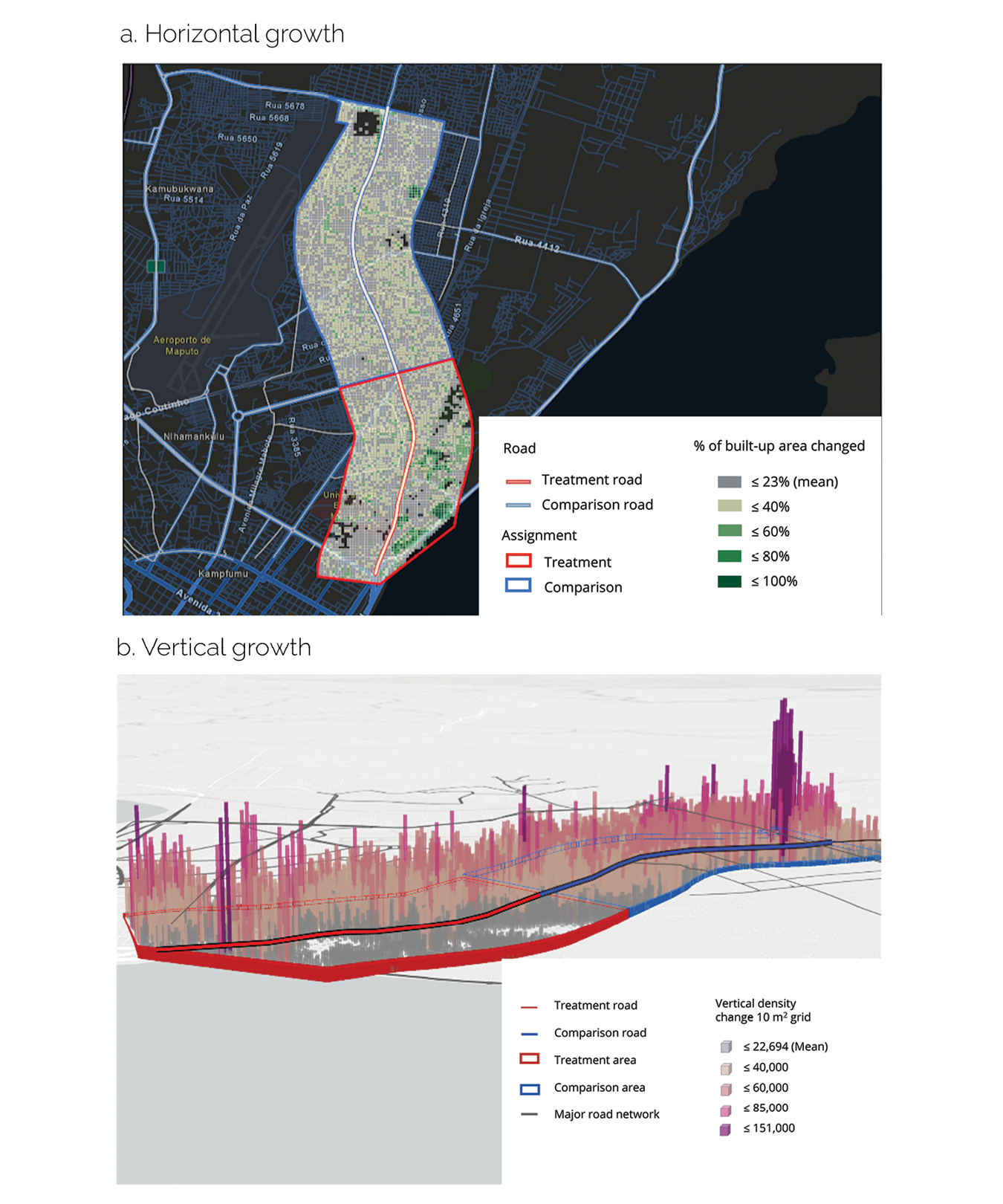
IEG undertook a pilot exercise in three transportation corridors financed by the World Bank to evaluate the impact of urban transport on land use. In Maputo, Mozambique, the World Bank financed the improvement of Julius Nyerere Avenue under the Maputo Municipal Development Program II (2009–17); in Mumbai, India, it financed two corridors—Santa Cruz–Chembur Link Road and Jogeswari–Virkhroli Link Road—under the Mumbai Urban Transport Project (2002–11). The analysis employed a quasi-experimental approach to evaluate changes of horizontal and vertical density of the built-up treatment and comparison areas. The treatment area was established within a 1,000–2,000-meter buffered area from the corridor; the comparison area was a zone that was near the improved road and had similar geographic characteristics to the treatment area. The detailed methodology is presented in appendix E.
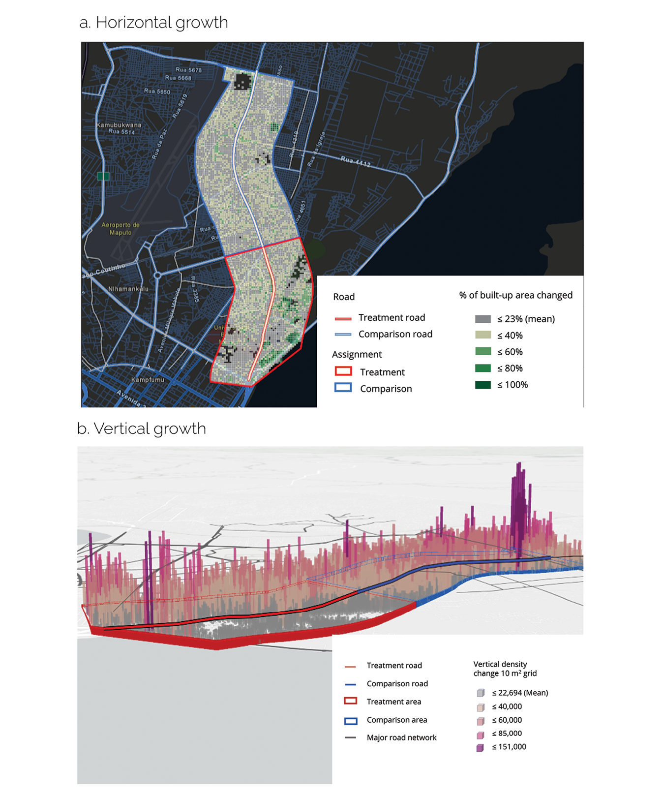
The corridor development in Maputo increased horizontal density, stimulating the urban land market. Maputo is the rapidly urbanizing capital city of Mozambique, with 1.1 million residents in 2010. Julius Nyerere Avenue contributed to increasing the horizontal density by 3.1 percent along the corridor compared with the comparison area (figure 3.2, panel a). The corridor development was instrumental in effectively developing underused sites within the built-up areas. But, as figure 3.2, panel b illustrates, the project’s contribution to vertical density was limited. In an IEG panel interview, 15 local real estate agents reported that the infrastructure improvements triggered real estate investments and higher density because the project significantly rehabilitated the road, reducing the risk of flooding, giving access to and from the city center, and opening the land market.
Figure 3.2. Horizontal and Vertical Growth of Maputo, Mozambique
Source: Independent Evaluation Group.
Note: The red lines show the areas treated by the project. The blue lines show the comparison areas. Each cell (a) represents 100 square meters; each cube (b) represents 1,000 cubic meters.
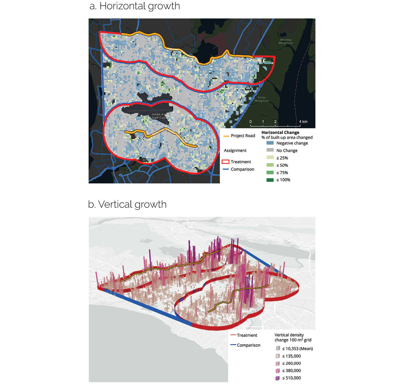
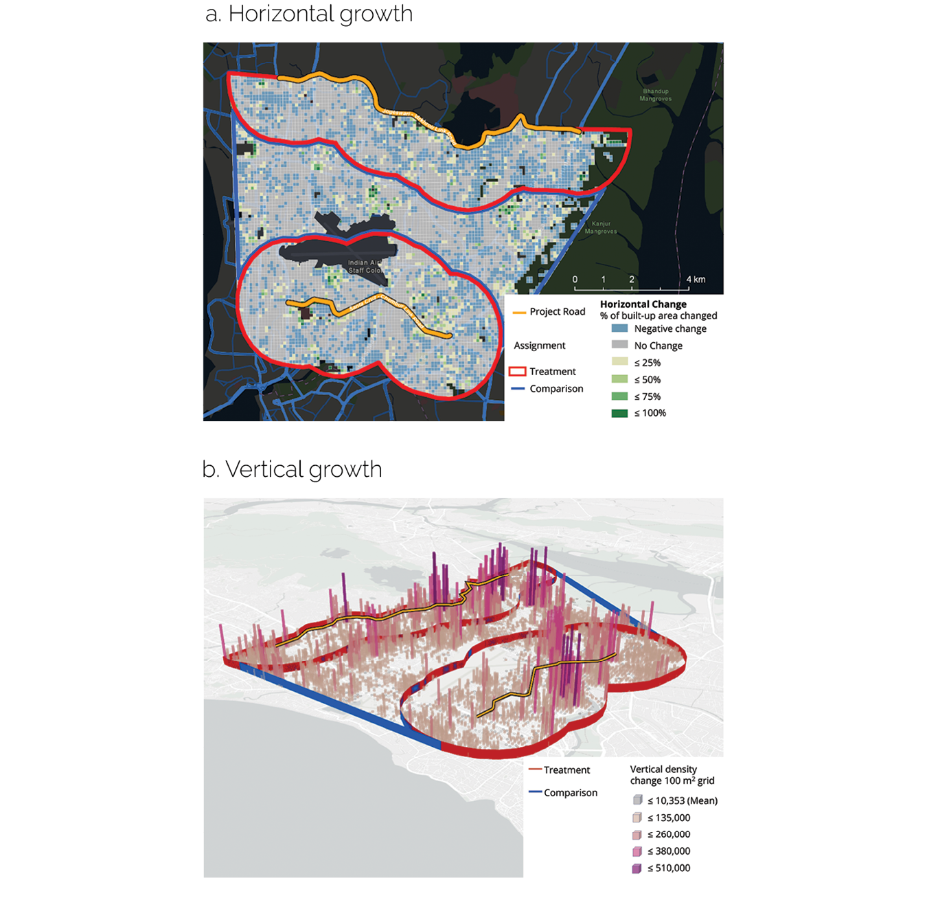
Spatially disorderly land-use patterns in Mumbai did not contribute to increased density along the improved roads. The two corridors created in Mumbai had limited impact on horizontal density. The increase in the horizontal density of the treatment area was 3.8 percent less than that of the comparison area (figure 3.3). There were no statistically significant results on vertical density. The density of land use was spread out and occurred in an irregular pattern. Such irregular patterns of change often discourage real estate investments because of reduced accessibility to transportation infrastructure (Salat and Ollivier 2017). The analysis of the Maputo and Mumbai corridors identified land-use outcomes that were not considered at the time of project design, underscoring the importance of integrating land-use planning with urban transport to catalyze wider economic benefits.
Figure 3.3. Horizontal and Vertical Growth of Mumbai, India
Source: Independent Evaluation Group.
Note: The red lines show the areas treated by the project. The blue lines show the comparison areas. Each cell (a) represents 100 square meters; each cube (b) represents 1,000 cubic meters.
Property Values in Urban Transport Projects
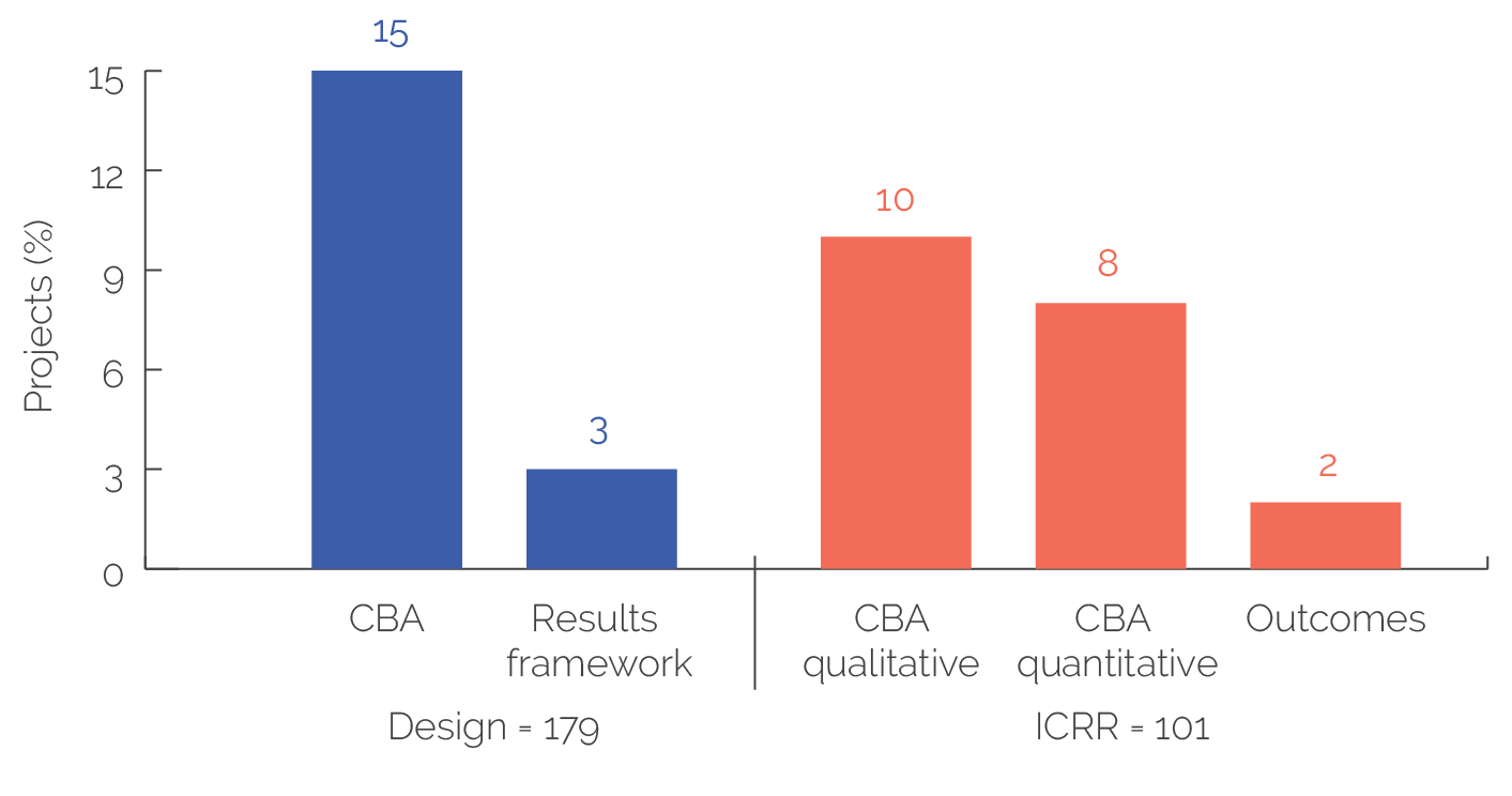
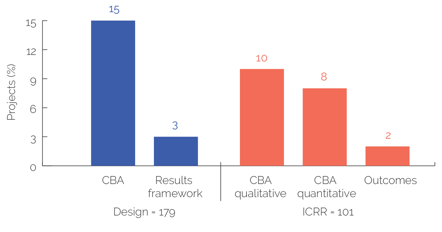
World Bank urban transport projects do not consider land values systematically. Because of the traditional focus on mobility and access, land-value considerations in urban transport projects remain limited. A review of 179 urban transport projects showed that at the time of design, 27 projects (15 percent) considered land markets in the cost-benefit analysis, and only 5 (3 percent) considered them in the results framework. At project completion, only 9 of 101 projects (9 percent) provided quantitative measures of land values, 8 provided qualitative measures of land values, and only 2 showed property values as outcomes in results (figure 3.4). More recently, World Bank advisory services and analytics have addressed the mobilization of finance through anticipating the economic impact of urban infrastructure. This approach aims to capture the wider development impacts of urban infrastructure investments, including property value increases (World Bank 2020c).
Figure 3.4. Consideration of Land and Property Values in Urban Transport Projects
Source: Independent Evaluation Group.
Note: Eight projects mentioned increases in property prices as outcomes but did not provide evidence. CBA = cost-benefit analysis; ICRR = Implementation Completion and Results Report Review.
Excluding land-value appreciation underestimates the total economic benefits of urban transport projects. In Colombia, the World Bank, as part of support to the Barranquilla BRT, considered direct and wider economic benefits. It estimated standard economic benefits including travel time reduction, operation cost reduction, greenhouse gas emission savings, and road accident savings. Wider economic benefits that included residential land–value increases were estimated at $245 million, 44 percent of the total economic benefits. By contrast, World Bank support to BRT in Bogota, Bucaramanga, and Pereira did not consider land-value increases, significantly underestimating economic benefits.
- As explained in chapter 1, the overall portfolio consists of all 527 projects related to the four determinants of managing urban spatial growth treated in this evaluation, whereas the focused portfolio is a subset of the overall portfolio consisting of 250 projects in 19 countries selected based on the intensity of World Bank engagement, urbanization level, and regional representation.
- Based on a development impact study carried out in 2013 covering 1,904 households in the three project provinces and a case study of Leyte’s land values carried out in 2010 (World Bank 2015a).
- A geographic information system is a framework for gathering, managing, and analyzing data about the spatial locations of objects.


